Historical Hike March 5 – Ye Olde Alpine Tavern/Mt Lowe Railway
Distance: ~ 7 miles total (out and back).
Gain: ~ 500′
Rated: Easy to Moderate
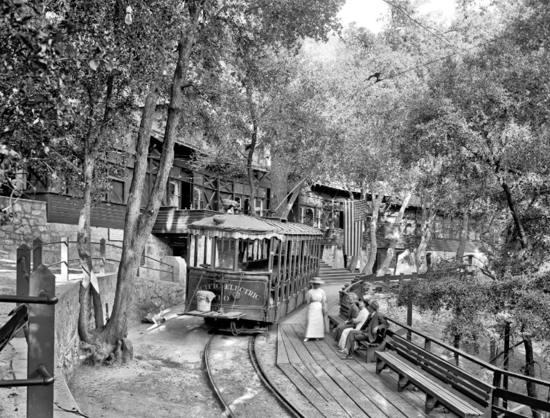
Description: Once everyone has arrived at Ye Alpine Tavern ruins, Club Historian, Alan Pollack, from the Santa Clarita Historical Society, will tell us the brief history of the tavern and the Mt. Lowe electric Railroad. The Railroad brought people to the tavern.
The Mt. Lowe Railway operated from 1893-1936. It is on the National Register of Historic Places, as of 1993. The train crossed 18 bridges between Echo Mountain and the Alpine Tavern. The one in front of the tavern was a large “S” shaped bridge. Both end foundations are still visible. The Tavern was built in 1895, destroyed by fire in 1936, and dynamited in 1959 to allow for the construction of the trail camp, as you will see it today.
NOTE: THERE ARE RESTROOMS in the tavern area for your convenience. (Bring TP…it is not always stocked).
Lunch, after the hike,? If you would like to visit Newcomb’s Ranch for lunch, a lite snack or a refreshing drink, bring money. It is about 10 miles farther up Highway 2. You can follow Dianne and Alan to this interesting Motorcycle Hangout.
Carpooling from Santa Clarita Valley:
Meet at Towsley Canyon parking area in front of the green gate at 9:00AM to arrange carpools. We will leave at 9:15AM SHARP for the trailhead.
(Please be respectful of your driver’s support by contributing something at the end of your carpool to help defray the cost of gas – THX).
Directions to Carpool meeting spot in Santa Clarita Valley: Exit the I-5 freeway in Santa Clarita Valley at Calgrove Blvd. Turn West and follow Calgrove around a curve and through one light. You will now see the gate to Towsley Canyon on your right. Park and look for a group of hikers/ leader.
Directions to the Hike starting point: From Santa Clarita, take the I-5 South to the 210 East. Exit the 210 at Hwy 2 Angeles Crest Hwy, North, into the mountains/ forest. Take Hwy 2 all the way to Mt Wilson/ Red Box Road. Turn Right.
You will immediately see the Native American Indian Cultural Center (Haramonkngna) on your right. Continue traveling on this road approximately 2.3 miles. There will be a turn out on the right AND the left side. Park on the right side, if there is space to park. To be sure you are in the correct location, look for a locked forest gate on the right, with the number 2N50 on the gate. This is where we will meet to start the hike at ~ 10:15AM (those going direct take note).
Bring: Water (3 liters is recommended), electrolytes if it is a hot day, sunscreen, hat, lunch/ snacks, hiking poles which can be helpful on the climb, and of course your camera. Wear layered clothing in case it gets hot or cold. Wear good boots with tread.
Historian: Alan Pollack
Hike Leader: Dianne